Showing posts with label Tourism. Show all posts

Is Morocco safe for tourists?

Is Morocco safe for tourists?


Check out this short youtube video interview we did in the Sahara Desert of Morocco:


Selena Moshell is a photographer and filmmaker and also a dancer in Los Angelos California in the United States of America.
Check out her website and her portfolio here: www.selenamoshell.com
She was visiting Morocco with her family in January 2019. While in this beautiful bivouac camp in the Sahara desert of Erg Chebbi after booking a three days / two nights Sahara desert trip from Fes to Marrakech, I took the chance to make a little interview with her about her trip to Morocco and what she thinks of it, and most importantly if she felt SAFE during her stay here, because a lot of tourists are worried about visiting the country after what happened last December.. Of course Any lost soul is a big tragedy, but statistically speaking, in the last decade only one incident happened, so it's safe to say that morocco IS actually SAFE compared to many other countries, including European ones like France for example, it had many attacks lately and many people were lost in them.
Second thing is that nowadays anything can happen anywhere, you can be in the comfort of your own town and a crazy person with a twisted idiology could mess up your day doing a crazy thing..
We wish peace and safety to everyone in the world..
We only talked about this issue to reassure the visiting tourists of the safety of our country, we do not usually bring up political or religious topics, because who wants to talk about sensitive topics on holidays? tourists want to relax and have great experience, not to engage in deep conversations, that's of course generally speaking, we do not mind on the other hand to discuss any topics including the sensitive ones mentioned above, Our highly educated team would be happy to give you any informations you need about any fild related to morocco, and you can ask any kind of questions you want, we will not be offended. 
We offer full Morocco tours, Sahara desert tours in both spots, Erg Chebbi of Merzouga and Erg Chgaga of Zagora,Imperial cities tour (Fes, Mekes, Rabat, Marrakech), North Tour (Tangiers, Assila, Chefchaouen), plus Agadir and Essaouira on the coast.. We also offer day trips from Marrakech to the Atlas mountains, Ouzoud waterfalls, the three rivers.. and many other things.. feel free to contact us with your inquiries. We are looking forward to welcoming you here among us and give you a taste of Moroccn hospitality, and also a taste of our delicious diverse food..
and again, here you can see, the Sahara desert welcomes everyone who wants to visit and have an experience of a lifetime.. the sunrise and sunset in the desert dunes are a must see, and if you're lucky enough and the sky is clear you could see soo many stars, or even the milkyway..
peace and love from the Sahara desert of Morocco.
Hyper Morocco Tours team

Imlil

Imlil Village - High Atlas mountains

Imlil Village is located at about 70 km from the city of Marrakech in the heart of the High Atlas Mountains in Morocco. It is about 1,800 metres (5,900 feet) above sea level. It is also very close to the mountain called "Jebel Toubkal", which is the highest peak in Northern Africa and the second highest in all Africa.

Watch this Youtube short video showing a day excursion trip to Imlil


Imlil village is a good base for people attempting to get all the way to the summit of Toubkal mountain. 
Because of its unique position, Imlil village is the most important part of mountain tourism in Morocco, because most visitors heading up to Toubkal mountain start their trikking Journey from Imlil. 
Imlil is the end of the road that a vehicle can reach, and is a natural place to hire mountain guides and mules for the onward mountain trekking and hiking. The area was expanded with time to cater for the number of tourists pouring through en route to Toubkal, it is relatively a new village. The original berber communities still exist in the valleys around Tamatert, Ait Souka, Tagadirt, Tacheddirt, Acheim, Taourirt n'Ait Mizane, Mzikene and Arhrene. 
Before the revolution of mountain tourism in Morocco, the Imlil region was pretty much known for the production of amazing walnuts, apples and delicious cherry. nowadays these are still important to the local and national economy, but they have been eclipsed by mountain tourism. Currently both mountain tourists and Moroccans come to Imlil seeking a cool relief from the heat of the region of Marrakech El-Haouz. 
The Film 'Seven years in Tibet' was partly filmed in the village.

Hyper Morocco Tours offers you the possibility to do a day trip to Imlil in a private vehicle, for more informations and booking feel free to contact us.

Ouzoud Waterfalls

Ouzoud Waterfalls

One day Excursion from Marrakech

A one day Excursion to Ouzoud waterfalls can be done from Marrakech, since it's only 150 km away, The excursion starts at around 8 in the morning from Marrakech. The road takes roughly 1 houre 30 min to 2 houres, with few stops for breakfast and panoramic views if you want to take pictures.
Upon arrival to the village where the Ouzoud waterfalls are located you have the choice to either take a local guide (costs around 2 Euros per person) or to go explore the area by yourself.


Watch this youtube video that shows how does a one day excursion to Ouzoud waterfalls from Marrakech usually goes:


Ouzoud Waterfalls (in Amazigh (berber) language: Imuzzar n wuẓuḍ, in French: Cascades d'Ouzoud) is 110 m high (second highest waterfalls in Africa). They are located in the province of Azilal, precisely near the Moyen Atlas village of Tanaghmeilt.

As you explore the region you will eventually have the chance to see some monkeys living in the wild. Some local habitant would  suggest that you feed them and they might give you bisquits in the hope that you would tip them afterwards. Olive trees are all over the area down the falls. That has to do with the word "Ouzoud" that means in Amazigh (berber) "the act of grinding grain", you might aswell come across some small mills that are still in use.

Cliff jumping is not safe in Ouzoud falls neither is swimming in some areas. But you will notice some cliff jumpers and swimmers here and there.

The Ouzoud waterfalls excursion will continue after lunch. there are many local traditional restaurants spread all over the place where you could eat, they mainly serve Moroccan Tagines. You will have the chance to eat in nature near water, or on a terrasse while enjoying the panoramic view.

Other activities you can do there is hiking in nature though the old mills, the green valleys , the beautiful orchards, and the gorges of the El Abid River (in Arabic, "Slaves' River" ).
Or you can ride a small traditional boat that would take you under the falls for about two euros per person (see video).

The Excursion ends by a meeting in the parking where you left the car, then you will head the road back to Marrakech.


Additional informations about Ouzoud Waterfalls:

There is possibility of camping in Ouzoud waterfalls. There are reserved places for camping where you can erect your tent and enjoy few days in one of the  most beautiful sites in Morocco.

Due to the increasing number of visitors with all the issues that come with it many local and notional associations are leading projects to protect and preserve the site.

So if you are in Marrakech do not miss the opportunity to live the experience of visiting Ouzoud Waterfalls, We offer one day Excursion there among our selected places we do excursions to. If you are interested feel free to contact us.

Paradise valley - Agadir


Paradise valley - Agadir


Paradise Valley is a section of the Tamraght River valley in the Moroccan Atlas mountains. It is located approximately 20 km north of Agadir. The valley is known for its abundance of rock pools and small waterfalls.
Most visitors to Paradise Valley travel onwards from the palm groves and gorges of the river Tamrhakht up into the mountains towards Imouzzer. The names of this and other villages differ according to whom or from where you are receiving your directions. This variance applies also to the names of valleys, estimates of distance, timetables of bus transport, and of course the cost of getting there and back. Getting to Paradise Valley and the mountains beyond requires a hire car or collective grand taxi.

Here you can see two youtube video of Paradise valley Agadir:
Part one

Part two

It was an amazing experience, the unfinished road might be a problem to reach paradise valley but mostly it is a good road, then you have to walk for about 20 mins in the valley, and that's fun because you will be walking in nature, among mountains, trees and water..
I also noticed some small "cafes" created by locals, the beautiful thing is that some of them have chairs on water so you can feel water running on your feet while you're having a drink as you could see in the video.
Paradise valley is in the middle of the road to Imouzzar, another nice place with beautiful waterfalls

This is a video of some Cliff Jumps in Paradise valley Idaoutanane:

some cliffs are pretty high, so if you are into cliff jumping then this area would satisfy your desire, waters are good, depending on what time of year you decide to visit, avoid the summer as it is way too crowded with both locals and tourists, best time of year to visit paradise valley is during the spring, between April and May, after the rain season is over and the level of water is a little high, and also everything around you would be green and the weather is mostly beautiful.

Agadir

Agadir

Agadir (Amazigh: Agadir, ⴰⴳⴰⴷⵉⵔ, Moroccan Arabic: أڭادير) is a major city in southwest Morocco, capital of the Agadir province (MA-AGD) and the Sous-Massa-Draa economic region. A majority of its inhabitants speak Amazigh as a mother tongue.

Agadir in video:


A video of Agadir Ouflla or The Casbah ruins:

The Casbah or Agadir Oufella:
The Casbah (Agadir Oufella, Agadir le haut, Agadir N'Ighir, or Agadir de la colline) was, along with Founti by the sea, the oldest district of Agadir. An authentic fortress with winding streets and lively, the Casbah was built in 1572 by Moulay Abdallah al-Ghalib. Above the front door; today, the original inscription in Arabic and in Dutch reads: "Fear God and honour the King."

Of this fortress there remains, after the earthquake of 29 February 1960, a restored long high wall that surrounds land that is not buildable. The view, however, is exceptional over the bay of Agadir and the ports. The old people of Agadir remember the famous "Moorish café" of the Casbah and its panoramic view.

The hill bears the inscription in Arabic: "God, Country, King" which, like the walls, is illuminated at night.


Etymology
The word Agadir means in Amazigh language "wall, masoned wall enclosing a town, fortress, town".

Description
Agadir has a population of 678,596 (2004; census figures for the agglomeration include the nearby cities of Inezgane and Aït Melloul). The population of the city proper is estimated at 200,000. The mild winter climate (January average midday temperature 20.5°C/69°F) and good beaches have made it a major "winter sun" destination for Northern Europeans.
The city is located on the shore of the Atlantic Ocean, near the foot of the Atlas Mountains, just north of the point where the Souss River flows into the ocean.
Agadir is an important fishing and commercial port, the first sardine port in the world, (exporting cobalt, manganese, zinc and citrus).It is also a seaside resort with a long sandy beach. Because of its large buildings, wide roads, modern hotels, and European-style cafés, Agadir is not a typical city of traditional Morocco, but it is a modern, busy and dynamic town.
Agadir is famous for its sea food and agriculture.

The city's main neighborhoods are:
Secteur Touristique-Taddart-Hay Adrar-Founty-Iligh-Sonaba-Ihchach-Les Amicales-La ville nouvelle-Nouveau Talborjt-Cité Suisse-Lakhiyam-Dakhla-Extension Dakhla-Al Houda-Salam-Riad Assalam-Hay al Hassani-Anza-L'Erac (Bouargane).-Quartier Industriel Tasila-Tilila-Quartier Residentiel-Quartier Al mohammadi

Chefchaouen or chawen


Chefchaouen or Chaouen

Chefchaouen is one of, if not the, most beautiful places to see in northwest Morocco, also called "the blue city" or "the blue town" because of the blue colors that dominates most of its buldings.
Watch the beauty of Chefchaouen in these videos:


In this second video you can see more of chefchaouen plus Akchour or "Akechour", wich is a beautiful natural place near chefchaouen, with breathtaking waterfalls and beautiful clean water:

More about Chefchaouen from Wikipedia:
Chefchaouen or Chaouen (Amazigh: ⵜⵛⴻⴼⵜⵛⴰⵡⴻⵏ Accawn, Arabic: شفشاون/الشاون, Spanish: Chauen, lit. "horns") is a city in northwest Morocco. It is the chief town of the province of the same name, and is noted for its buildings in shades of blue.Chefchaouen is situated in the Rif Mountains, just inland from Tangier and Tetouan. The city was founded in 1471, as a small fortress which still exists to this day, by Moorish exiles from Spain led by Moulay Ali Ben Moussa Ben Rached El Alami to fight the Portuguese invasions of northern Morocco. It was known as one of the main concentrations of Moriscos and Jews who sought refuge in this mountainous city after the Spanish Reconquista in medieval times. In 1920, the Spanish seized Chefchaouen to form part of Spanish Morocco. Spanish troops imprisoned Abd el-Krim in the kasbah from 1916 to 1917, after he talked with the German consul Dr. Walter Zechlin (1879–1962). (After defeating him with the help of the French force Abd el-Krim was deported to Réunion in 1926). Spain returned the city after the independence of Morocco in 1956.


Ifrane


Ifrane


Ifrane Morocco in video:


Ifrane (Arabic: إفران/يفرن‎; Amazigh: ⵉⴼⵔⴰⵏ/ ⵢⴼⵔⵏ Ifran) (nicknamed Little Switzerland) is a town and ski resort in the Middle Atlas region of Morocco  (population 73,782 in November 2014). Ifrane is 1665 metres (5,460 ft) in altitude and is part of the Meknès-Tafilalet region. In Tamazight, the regional Amazigh language, "ifran" means caves.

One of the cleanest cities in the whole world

Background
Developed by the French during the protectorate era for their administration due to its Alpine climate, this Moroccan town has a remarkable European style, as if it were an Alpine village. Because of its elevation, the town experiences snow during the winter months and a cool climate during the summer. Ifrane is also the place where the lowest temperature was ever recorded in Africa, -24 °C in 1935. Animals to be found in the vicinity include the threatened Barbary Macaque. Among the local tree species are the native Atlas cedar, Scrub oak and the introduced London plane.
The first permanent settlement of the area dates to the 16th century, when a saintly sharîf by the name of Sîdî 'Abd al-Salâm established his community in the Tizguit Valley, seven km downstream from the present town. By the mid-17th century the zâwiyah was well enough established to receive an extensive iqtâ' (land grant) from the 'Alâwî sultan Mûlây Rashîd b. Muhammad. While the founder's lineage was ethnically Arab, the inhabitants of the village today mostly speak Tamazight.
Ifrane is a colonial “hill station,” and a “garden city.” It is also an “imperial city,” a mountain resort, a provincial administrative center, and a college town.


Al Hoceima

Al Hoceima (Amazigh: Biya or El-Ḥusima, Arabic: الحسيمة) is a city and in the north of Morocco on a northern edge of the Rif Mountains, on the Mediterranean coast. Al Hoceima and its surrounding regions have a population of 395,644 (2004 census). Al Hoceima city is the capital of the Taza-Al Hoceima-Taounate region. It is situated in the territory of the Ayt Weryaghel and Ibeqquyen tribes of the Rif, who speak Tarifit Berber, locally called Tamazight.
History
The Spanish started to develop Al Hoceima around 1925. General Sanjurjo landed with his troops on the beach of Al Hoceima during the Rif Rebellion and claimed the territory for Spain. He named the territory Villa Sanjurjo, after himself. Many locals still refer to the city as "Villa".

The Spanish troops built houses, schools and hospitals above the beach, creating the beginnings of the town. In the 1920s and '30s the town had almost no growth in population. Its name changed from Villa Sanjurjo to Villa Alhucemas, and the few streets above the beach were still occupied by mainly Spanish soldiers and their families. The first major was Florian Gómez Aroca.

After Morocco gained its independence in 1956, Al Hoceima developed quickly, and the Moroccan government changed its name from the Spanish Villa Alhucemas to Al Hoceima.

Tetouan

Tetouan (from the Berber Tiṭṭawin, Arabic: تطوان, Spanish: Tetuán, French: Tétouan) is a city in northern Morocco. The Berber name means literally "the eyes" and figuratively "the water springs". Tetouan is one of the two major ports of Morocco on the Mediterranean Sea. It lies a few miles south of the Strait of Gibraltar, and about 40 mi (60 km) E.S.E. of Tangier. In 2004 the city had 320,539 inhabitants (census figure). Tetouan's civil airport Sania Ramel Airport is located 6 km to the east.

Arabic is the official language but it is not used for everyday dialogue. The city has its own dialect, a particular citadin variant of non-hilalian Arabic which is distinct from Jebli Arabic. However, Jebli Arabic is predominant since people from the neighboring rural areas settled in the city during the 20th century rural flights. The use of Spanish and French is still widespread especially by the businessmen and intellectual elites. Its main religion is Islam. A small Christian minority lives in the city.

Tanger or Tangiers

Tangier or Tangiers (UK: /tænˈdʒɪə/, US: /tænˈdʒɪr/; Berber: Tanja or (archaic) Tingi, Arabic: طنجة Ṭanjah), is a city in northern Morocco with a population of about 700,000 (2012 estimates). It lies on the North African coast at the wester
n entrance to the Strait of Gibraltar where the Mediterranean meets the Atlantic Ocean off Cape Spartel. It is the capital of the Tangier-Tetouan Region and of the Tangier-Asilah prefecture of Morocco.

The history of Tangier is very rich due to the historical presence of many civilizations and cultures starting from the 5th century BC. Between the period of being a Berber settlement and then a Phoenician town to the independence era around the 1950s, Tangier was a refuge for many cultures. In 1923, Tangier was considered as having international status by foreign colonial powers, and became a destination for many European and American diplomats, spies, writers and businessmen.

The city is currently undergoing rapid development and modernization. Projects include new 5-star hotels along the bay, a modern business district called Tangier City Center, a new airport terminal and a new football stadium. Tangier's economy is also set to benefit greatly from the new Tanger-Med port.

Tangier's sport team I.R.T. (or Ittihad Riadi de Tanger) is a prominent football club with a large following base. Tangier will be one of the host cities for the 2015 Africa Cup of Nations football tournament, which shall be played at the new Ibn Batouta Stadium and in other cities across Morocco.

Marrakech


Marrakech

Marrakech or Marrakesh (Amazigh: ⵎⴻⵕⵕⴰⴽⴻⵛ, Merrakec, or Murakuc, Arabic: مراكش Murrākuš, local pronunciation: Mərrakəš), known as the "Ochre City", with a population of over 1,000,000 inhabitants is the most important former imperial city in Morocco's history. The city of Marrakesh is the capital of the mid-southwestern economic region of Marrakech-Tensift-Al Haouz, near the foothills of the snow-capped Atlas Mountains, being also the third largest city in Morocco according to the 2004 census.

 Like many Moroccan cities, the city of Marrakesh comprises both an old fortified city (the medina) and modern neighborhoods, the most prominent of which is Gueliz, for a total population of 794,620 and 1,063,415 in the metropolitan area (2004 census). It is served by Ménara International Airport (IATA code: RAK) and a rail link to Casablanca and the north.

 Marrakesh has the largest traditional Amazigh market (souk) in Morocco and also has one of the busiest squares in Africa and the world, Djemaa el Fna. The square bustles with acrobats, story-tellers, water sellers, dancers and musicians. By night food stalls open in the square turning it into a huge busy open-air restaurant.

Quick tour in Marrakech in this video:


Marrakech in the 50s in Video:


More photos of Marrakech:

Ouzoud Waterfalls

Ouzoud Waterfalls (French: Cascades d'Ouzoud) (110 m high) are located in the Grand Atlas village of Tanaghmeilt, in the province of Azilal, 150 km north-east of Marrakech, in Morocco.

Ouzoud is the Amazigh word for "olive", referring to the nearby olive trees.

The bottom of the falls is accessible through a shaded path of olive trees. At the summit of the falls, there exist a dozen of old small mills that are still in use. One can also follow a narrow and difficult track leading to the road of Beni Mellal while descending the gorges from the "wadi el-Abid" by a canyon sometimes which one does not distinguish the bottom with nearly 600 metres.

It is the most visited site of the region. In the vicinity, Green valleys, mills, orchards and a superb circuit of the gorges of the El Abid River (in Arabic, "Slaves' River" ), are found. Many local and national associations lead projects to protect and preserve the site.

Rabat


Rabat

Rabat (Arabic الرباط; Amazigh ⵕⴱⴰⵟ, transliterated ar-Rabāṭ or ar-Ribāṭ or (Er-)Rbāṭ, literally "Fortified Place"; French Ville de Rabat; Spanish Ciudad de Rabat), is the capital and third largest city of the Kingdom of Morocco with a population of approximately 650,000 (2010). It is also the capital of the Rabat-Salé-Zemmour-Zaer region.

Rabat on Video HD

The city is located on the Atlantic Ocean at the mouth of the river Bou Regreg. On the facing shore of the river lies Salé, the city's main commuter town. Together with Temara the cities account for a combined metropolitan population of 1.8 million. Silting problems have diminished the Rabat's role as a port; however, Rabat and Salé still maintain important textile, food processing and construction industries. In addition, tourism and the presence of all foreign embassies in Morocco serve to make Rabat one of the most important cities in the country.

Rabat is accessible by train through the ONCF system and by plane through the nearby Rabat-Salé Airport.


Rabat in the 50s in video:


More photos of Rabat:

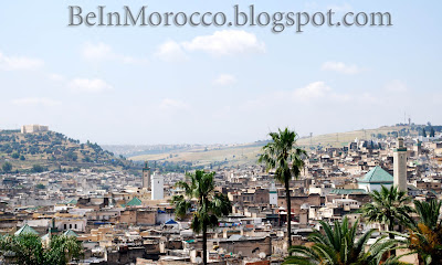
Fes


Fes - Fez

Fes or Fez (Arabic: فاس‎ Arabic pronunciation: [fɛs]) is the second largest city of Morocco, with a population of approximately 1 million (2010). It is the capital of the Fès-Boulemane region.

Fas el Bali is a UNESCO World Heritage Site. Its medina, the larger of the two medinas of Fes, is believed to be the world's largest contiguous car-free urban area. Al-Qarawiyyin, founded in AD 859, is the oldest continuously functioning madrasa (university) in the world. The city has been called the "Mecca of the West" and the "Athens of Africa".


Fes in the 50s in Video:


Fes is one of the imperial cities in Morocco, It was the capital of Morocco many times throughout history.. also known as the house of  manufacturing location for leather goods.
Some researches refer to the city of fes as the religious capital of Morocco, visitors and tourists can actually sense the strong presence of Mosques in the city. Also because Al-Qarawiyyin is one of the famous Islamic universities in the world.
In the past few years, Fes has become one of the popular tourist destinations in Morocco, especially tourists that are interested in imperial cities and historical places. That's what pushed many non-Moroccans to restore traditional riads (old houses) and transform them into second houses or small hostels in the Fez medina.
One more event that the city of Fes is famous for is the sacred music festival. Founded back in 1994 and held every year for a whole week, the music festival of Fes has been visited by millions and been animated by many famous artist from all over the world.
Fes has its own international Airport "Fes-Saiss", 15km to the south with over 500000 passenger every year.

If you are interested in starting your tour from Fes contact us through our contat page
We offer Morocco tours and excursions from Marrakech, Fes, Casablanca, and Agadir. We will be glad to organize your morocco tour with you.


More Photos of Fes:


Meknes


Meknes

Meknes (Arabic: مكناس‎, Amazigh: ⵎⴽⵏⴰⵙ Mknas or Ameknas, French: Meknès, Spanish: Mequinez) is a city in northern Morocco, 130 kilometres (81 mi) from the capital Rabat and 60 kilometres (37 mi) from Fes. It is served by the A2 expressway between those two cities and by the corresponding railway. Meknes was the capital of Morocco under the reign of Moulay Ismail (1672–1727), before it was relocated to Marrakech. The population is 985,000 (2010 census). It is the capital of the Meknes-Tafilalet region. Meknes is named after a Berber tribe which was known as Miknasa (native Berber name: Imeknasen) in the medieval North African sources.

Meknes in the 50s:


More Photos of Meknes:


Casablanca


Casablanca


Casablanca (Arabic: الدار البيضاء ad-Dār al-Bayḍāʼ, original name in Berber: ⴰⵏⴼⴰ Anfa) is a city in western Morocco, located on the Atlantic Ocean. It is the capital of the Grand Casablanca region.

Casablanca is Morocco's largest city as well as its chief port. It is also the biggest city in the Maghreb region. The 2004 census recorded a population of 2,949,805 in the prefecture of Casablanca and 3,631,061 in the region of Grand Casablanca. Casablanca is considered the economic and business center of Morocco, while the political capital city of Morocco is Rabat.

Casablanca hosts headquarters and main industrial facilities for the leading Moroccan and international companies based in Morocco. Industrial statistics show Casablanca retains its historical position as the main industrial zone of the country. The Port of Casablanca is one of the largest artificial ports in the world, and the largest port of North Africa. It is also the primary naval base for the Royal Moroccan Navy.

Casablanca in video:

More photos:


Morocco: Weather

Morocco: Weather

 One of the things that any visitor or tourist ask about before booking a tour or an excursion in Morocco is the weather. especially if they want to book a tour to the desert of Merzouga and do camel trekking, because it can be very hot there at times, especially in July and August. On the other hand tourists that are interested in visiting the beaches like Agadir are more into sun, while the ones interested in surf for example are looking for the wind that they usually find in Essauira. Lucky for all those visitors, Morocco has everything they want.


Weather in morocco is so mosaic too as morocco is, in one single day you can feel how cold is the atlas mountains then you can drive some hours to feel yourself too hot at the sahara dunes and oasis.

at the coasts reign the oceanic moderated climat, at the northen band the mediterranean cool climat sometimes cold.

weather at the atlas mountains (inland) is cold and very influenced by height with his snowfall winter, in the south reign the saharian hot climat.

sunshine levels are more than 10 in marrakech , fez , agadir and ouarzazate.


Depending on the places you want to visit in Morocco, make sure you pick the best time of year before booking your tour.

Morocco: History (part 1)


Morocco: History (part one)


If you are interested in tours and excurions around imperial cities and historical places you may also be interested in knowing a little bit about the history of morocco

Prehistoric Morocco
In 1971 the fossilised bones of a 400,000 year old early human ancestor was discovered at Sale. In 1991 the bones of several very early Homo sapiens were discovered at Jebel Irhoud that are at least 160,000 years old[1]. In 2007 small perforated sea shell beads were discovered in Taforalt that are 82,000 years old, which makes them the earliest evidence of personal adornment yet found anywhere in the world.

The Capsian culture brought Morocco into the Neolithic about 2001 BC, at a time when the Maghreb was less arid than it is today. The Berber language probably was formed at roughly the same time as agriculture, and was developed by the existing population and adopted the immigrants who arrived later. Modern DNA analysis has confirmed that various populations have contributed to the present-day gene pool of Morocco in addition to the main ethnic group which is the Amazighs/Berbers. A very small percentage of those other populations are Iberians and sub-Saharan Africans.

In Mesolithic ages the geography of Morocco resembled a savanna more than the present day arid landscape. While little is known about Morocco settlement in these early times, excavations elsewhere in the Maghreb suggest an abundance of game and forests that would have been hospitable to Mesolithic hunters and gatherers.

The coastal regions of present-day Morocco shared in an early Neolithic culture that was common to the whole Mediterranean littoral. Archaeological remains point to the domestication of cattle and the cultivation of crops in the region during that period. Eight thousand years ago, south of the great mountain ranges in what is now the Sahara Desert, a vast savanna supported Neolithic hunters and herders whose culture flourished until the region began to desiccate as a result of climatic changes after 4000 BC.

Phoenicians on the coast
Phoenician traders, who had penetrated the western Mediterranean before the 12th century BC, set up depots for salt and ore along the coast and up the rivers of the territory that is now Morocco. The arrival of Phoenicians heralded many centuries of rule by foreign powers for the north of Morocco. Major early substantial settlements of the Phoenicians were at Chellah, Lixus and Mogador, with Mogador being a Phoenician colony as early as the early 6th century BC. Carthage developed commercial relations with the Berber tribes of the interior and paid them an annual tribute to ensure their cooperation in the exploitation of raw materials.

By the 5th century BC, Carthage had extended its hegemony across much of North Africa. By the 2nd century BC, several large, although loosely administered, Berber kingdoms had emerged.

Read Part two here

Basic informations about Morocco


 Basic informations about Morocco

Morocco is not only a holiday destination for tours and excursions, apart from being a touristical attraction for its famous sand dunes desert, imperial cities, moutains and beaches, Morocco is also an old country that is very rich and diverse culturally.
So if you have a chance to visit Morocco make sure to have a taste of the real thing. 
Here is a short description so you can have an idea:

Morocco (Arabic: المغرب‎ al-Maghrib ; Amazigh: ⴰⵎⵕⵕⵓⴽ or ⵍⵎⴰⵖⵔⵉⴱ "Ameṛṛuk" or "Lmaɣrib"), officially the Kingdom of Morocco, is a country located in North Africa. It has a population of over 32 million and an area of 710,850 km² . Despite being situated in Africa, Morocco remains the only African state not to be a member of the African Union due to its unilateral withdrawal on November 12, 1984 over the admission of the so called (Sahrawi Arab Democratic Republic) in 1982 by the African Union as a full member without the organization of a referendum of self determination in the disputed territory of  Sahara.

Morocco is a constitutional monarchy with an elected parliament. The King of Morocco holds vast executive and legislative powers, including the power to dissolve the parliament. Executive power is exercised by the government but the king's decisions usually overwrite those of the government if there is a contradiction. Legislative power is vested in both the government and the two chambers of parliament, the Assembly of Representatives and the Assembly of Councillors. The king can also issue decrees called "dahirs" which have the force of law. The latest Parliamentary elections were held on November 25, 2011, and were considered by some neutral observers to be mostly free and fair. Voter turnout in these elections was estimated to be 43% of registered voters, but only about 25% of Moroccan adult citizens actually voted. The rest either chose not to vote or they were not registered as voters, thus not allowed to vote. The political capital of Morocco is Rabat, although the largest city is Casablanca; other major cities include Marrakesh, Tetouan, Tangier, Salé, Fes, Agadir, Meknes, Oujda, Kenitra, and Nador.

Almost all Moroccans speak either Amazigh or Moroccan Arabic as mother tongues. Hassaniya Arabic, sometimes considered as a variety of Moroccan Arabic, is spoken in the southern provinces  in the country by a small population.

source: Wikipedia

 
Contact informations: Hyper Morocco Tours

Smail Jarrou
Quartier Elmhamid 9
Marrakech 50000 Morocco
Email 1: contact@hypermoroccotours.com
Email 2: hypermoroccotours@gmail.com
Tel / Whatsapp: Soon